The Legacy of Mississippi Asylum Life… and Death
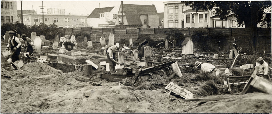
In 2013, while constructing a road on campus at the University of Mississippi in Jackson, workers uncovered sixty-six previously uncharted coffins. Work stopped to allow their removal to the university’s archeology center and the administration considered the matter closed. Then in 2014, during construction of a parking garage, approximately two thousand additional coffins were identified using ground penetrating radar; and the university realized it had a much larger issue on its hands. Now, three years later, the university administration believes it has finally discovered the scope of the bodies buried on campus after a larger radar investigation identified more than 7,000 coffins buried in twenty acres of land. Where did the bodies come from and how will the university deal with so many dead?

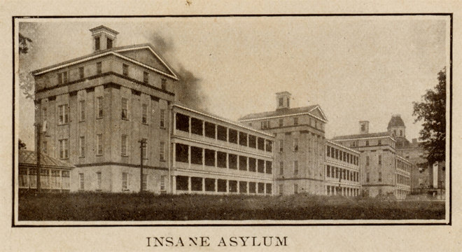
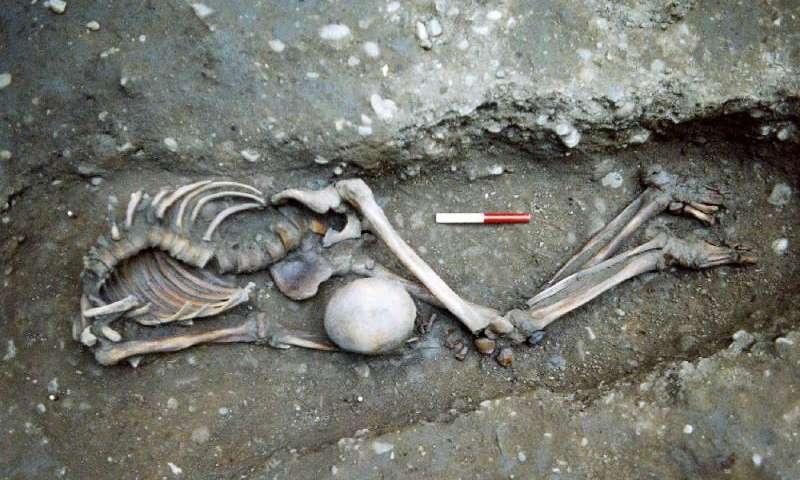
The source of the bodies is clearly based in the history of the area—the site was the location for the Mississippi State Lunatic Asylum, later called the Insane Hospital, which opened in 1855 and functioned until its closure in 1935. That hospital was later torn down to allow for the building of the current University of Mississippi Medical Center. People suffering from mental illnesses such as depression and schizophrenia were sent to live at the asylum where they could be treated as medical knowledge of the time dictated. Thousands died while still in the care of the state, and if their bodies were not claimed by family, they were buried in unmarked graves to the east of the asylum. The hospital kept records, and while some still remain, many are lost to history. While hand-drawn maps from the nineteenth century suggested the possible location of the cemetery, they did not indicate the scale—so the sheer size of the cemetery was a surprise to the university administration.

While the university is thrilled with the archeological and forensic treasure trove, practicalities must be considered. The cost of excavating over 7,000 coffins and reburying the remains is immense—an initial estimate placed it around $21,000,000 (approximately $3,000 per body). But the university plans to do the excavations in-house with their own Department of Anthropology, bringing the cost down to just over $3,000,000 over eight years. They intend to open a memorial and a new visitor center to highlight the history of the asylum, institutionalization, and healthcare in the pre-modern period. There are also plans to open a lab to study the remains.

Researchers hope to shed light on the institution itself and their methods of treating mental illness. Previous to the asylum, those suffering from mental illness were often jailed or kept prisoner in attics. Life in the asylum was likely not much easier, and the institution’s nineteenth century death rate averaged over twenty percent each year. Despite this, its population soared by 1900%—from approximately 300 patients in the late nineteenth century to the early twentieth century when it housed 6000 patients at its zenith. When the hospital closed, the patients were relocated to the state hospital in Whitfield, which is still open today.

There is a lot of personal interest within this discovery as well. Mental illness was so stigmatized in the past that suffering relatives simply ‘disappeared’ when they were shipped off to facilities such as the Mississippi State Lunatic Asylum. Within the local community there is a movement for possible descendants to donate DNA for comparison to the DNA of the remains in hopes of finding some of their own past.

Photo credit: University of Mississippi Medical Center


The Strange, Grim Tale of Colma, Califorinia

Colma, a tiny incorporated town of less than two square miles, is located on the San Francisco peninsula, just south of the city of San Francisco proper. It has the strange distinction of its living residents being outnumbered by the dead by over 1,110 to 1. A 2010 census placed the town’s population at 1,270, while its cemeteries hold more than 2,000,000 bodies. It's known as the City of the Silent, and has the humorous slogan 'It's great to be alive in Colma!' But how on earth did this city of the dead come to be?

Likely to no one’s surprise, it was a financial decision that drove the creation of Colma as we know it today—one all about skyrocketing land values in San Francisco. Even before the catastrophic earthquake of 1906, San Francisco had banned the construction of new cemeteries. But as the residents rebuilt following the devastation and land was in ever greater demand, the city passed a law in 1912 evicting all the dead from within the city limits. Needless to say, this decision wasn’t without controversy. The Catholic Church opposed the removed of remains from the Calvary Cemetery because the dead were interred on hallowed ground. Still others objected to the indignity of exhuming a number of the city’s pioneers and founders who were buried at the Lauren Hill Cemetery. Finally, the law was upheld. But where do you move nearly 160,000 bodies and how do you carry out this feat? The answer in the end was Colma, a tiny community just south of the city built along the El Camino Real, or the King’s Highway, and the associated railway line.

Digging up the dead at the Old Fellows Cemetery, San Francisco, Calfornia.

Digging up the dead at the Old Fellows Cemetery, San Francisco, Calfornia.

It was a task that took decades, from the 1920s to the 1940s. Odd Fellows Cemetery held 26,000 dead and it took more than 6 years to move them all to Greenlawn Memorial Park, as well as the 40,000 remains transferred from the Masonic Cemetery to Woodlawn Park. World War II interrupted the moving of 35,000 sets of remains from Lauren Hill Cemetery to Cypress Lawn in Colma. The remains had to be held in the Cypress Abbey Mausoleum since building the mausoleum meant as their final resting place was delayed by the war. But it was moving the remains of the 55,000 Catholic souls from Calvary Cemetery to Holy Cross that proved to be the most daunting as the Catholic Church would only support the transfer if each deceased was moved one at a time, properly screened for privacy, and with a priest in attendance. Only when this proposal was approved would the Archdiocese allow the removal of the remains starting in 1937.

Normal
0


false
false
false

EN-US
X-NONE
X-NONE


 <w:LatentStyles DefLockedState="false" DefUnhideWhenUsed="true"
DefSemiHidden="true" DefQFormat="false" DefPriority="99"
LatentStyleCount="267…

Woodlawn Cemetery, Colma, California

However, due to incomplete buried records, some of the oldest interred inhabitants of San Francisco were missed when the previous cemetery grounds were utilized to build colleges, parks, businesses, and housing. The Golden Gate Cemetery, founded in 1868, was turned into the Lincoln Park Golf Course and the associated Palace of the Legion of Honor Museum. During a retrofit of the museum in 1993, over a thousand coffins and sets of remains were unearthed. None of the city’s death records survived the earthquake and the raging fire that followed, but it is estimated that potentially up to 16,000 dead are still interred on the Lincoln Park property. With time, they could be discovered, but who they are will forever be a mystery. Care was taken to bury the dead as best as could be deduced from the remains themselves: Those holding rosaries were transferred to the Catholic cemeteries, while those identified as Chinese were buried in the Green Street Mortuary.

Normal
0


false
false
false

EN-US
X-NONE
X-NONE


 <w:LatentStyles DefLockedState="false" DefUnhideWhenUsed="true"
DefSemiHidden="true" DefQFormat="false" DefPriority="99"
LatentStyleCount="267…

Buena Vista Park gutter, created from an old gravestone

It’s a strange tale of the power of greed balanced by the human need to respect those who have passed on before us. Sadly, following the removal of the remains, the original tombstones and much of the cemetery art—including Neoclassical, Gothic and Egyptian statuary—were either crushed as material for gutters or a breakwater near the St. Francis Yacht Club, or were simply disposed of by dropping them into the bay. In addition, during moving of the remains, many were buried unidentified in mass graves or were buried under the wrong name, their true identities lost forever. However, many notable persons are buried in Colma, including Wyatt Earp, William Randolph Hurst, Levi Strauss, and Joe Dimaggio.

Photo credit: San Francisco Public Library (Odd Fellow Cemetery and Woodlawn Cemetery) and Chinasaur

Kennewick Man Goes Home

On July 28, 1996, two participants in an annual hydroplane race on the Columbia River found a skull in a local reservoir outside of Kennewick, Washington. After it was determined the remains were historical rather than a relatively fresh death, the skull was passed on to archeologist James Chatter, who instantly knew he had something interesting. In just under a dozen trips back to the reservoir, Chatters collected 350 pieces of bone—many of them fractured into several pieces—with only the sternum and several small hand and foot bones never recovered.

Chatters originally estimated the skeletal remains to have come from the 19th century based on damage and bone weathering. He also posited the remains were from a right-handed male of roughly 40–55 years of age, 5’7” to 5’9”, and of a slight build but with significant musculature—this was a man used to hard physical labour. He’d also had a hard life, having five broken ribs that had healed during his life, and two shallow depression fractures in his skull. A 3.1” cascade point—a Native American pointed projectile that was likely the piercing end of an arrow or spear—was found lodged deep in the man’s hip. The bone had partially remodeled over it, indicating it had been there for some time during his life. Radioisotope analysis of the bones revealed the man had consumed a diet of marine animals for several decades of his life. He had also consumed glacier melt water. Since at that time, the only glacier melt water to be found was in Alaska, this suggested the man was a coastal traveler. It was determined that he had been purposefully buried, lying on his back, his arms at his sides, palm down.

Most important for the unforeseen decades-long legal battle hidden just over the horizon, Chatters documented that he felt the skeleton portrayed Caucasoid traits and was lacking in Native American characteristics, marking the man as European in origin. So while interesting, the remains appeared to be that of a European explorer in the newly opened American West and beyond.

However, the story radically changed when a fragment of bone was sent for carbon-14 testing for a more accurate age determination. Shockingly, the results dated the skeletal remains to between 8,900–9,000 years old dating to nearly 7,000 B.C. This put an entirely new spin on the skull appraisal: Skulls older than 8,000 years do not have as much similarity to modern skull morphology, so a comparison to modern races using present day characteristic data points could not be made. The newly determined age of the skull, paired with the evidence of an ancient Native American weapon gave the local tribes everything they needed to declare the remains to be Native American in origin and to ask for their return. The ‘Ancient One’ deserved to be re-interred with his people as per the Native American Grave Protection and Repatriation Act (NAGPRA), rather than be displayed under lights and glass in a museum.

Because the remains were found on federal land under the jurisdiction of the United States Army Corp of Engineers, they remained in their care while the legal aspects of the case were examined. A first attempt to run DNA analysis on the remains early in this century was unsuccessful due to insufficient technology of the time. However, as DNA technology improved by leaps and bounds in the following decade to the extent that we can now sequence the 14th century bubonic plague and the 16,000 year old woolly mammoth genome, a new attempt was made to sequence the genome of Kennewick Man. This time scientists were successful and it was determined that Kennewick Man was more closely related to Native American tribes than to any European lineages. In fact, researchers determined that both Kennewick Man and modern Native Americans evolved from a common ancestor who lived approximately 9,200 years ago.

Last month these DNA results were confirmed by researchers at the University of Chicago, and the Army Corps of Engineers recently announced that they would release the remains for burial. Now all that remains to be determined is who will welcome the Ancient One. Five separate local tribes—the Colville, Yakama, Umatilla, Nez Perce, and Wanapum—have all laid claim to the remains. For the time being, the remains will remain in storage at the Burke Museum in Seattle, but there is hope that by 2017, repatriation will be determined and the bones will be released. Kennewick Man is coming home and will be finally laid to rest with the people who came from him and his people.

Photo credit: Chip Clark, Smithsonian Institution

A Second Viking Settlement Discovered in North America

Newfoundland coastline

Newfoundland coastline

Last week, we talked about the science of space archeology, and how, with the help of high resolution satellite scans taken 400 miles above the earth, a well-trained and intuitive eye can discern archeological sites hidden on the earth’s surface. This week, we’re going to talk about Dr. Sarah Parcak’s latest amazing discovery based on this technology.

The Vikings were a group of Scandinavians, first known for their international trading, but later known universally for their violent raiding of other lands and cultures. They were groundbreaking nautical engineers for the time and their carefully crafted vessels allowed them to travel from present day Norway, Sweden, and Denmark to Britain and Scotland, Russia, Turkey, Iran, and even all the way to North America.

The Vikings used water to move between locations, be it rivers to move through Europe proper or the Atlantic Ocean and Mediterranean Sea to go further. Starting in the 8th century, they set out to trade with peoples in other lands, but quickly learned that it was more successful and lucrative to simply raid those lands instead. They spread across the north Atlantic, moving from Scotland to Iceland, and then to Greenland.

But how did they so successfully set off into the unknown, and not be lost forever at sea? The Vikings were not only expert naval engineers, but were also expert navigators. They learned how to be able to detect land up to 50 or 60 miles away, simply by watching distant clouds, identifying sea birds out for a day of fishing, or by the smell of grass and other plants, carried by the strong sea breezes.

One of the great Viking explorers was Erik Thorvaldsson, better known as Erik the Red. Erik was part of an Icelandic settlement before he was exiled for three years in 982 A.D. after he murdered several members of the settlement. He and his men set sail, only to discover Greenland. It was Erik’s son, Leif Erikson, who is credited with the discovery of North America. He and his men sailed from Greenland, but were caught in a storm and driven due west, where they discovered a previously unknown coastline. Scholars studied the Viking texts of the time and believe Erikson found Baffin Island in Canada. From there he sailed south, down to Labrador, and then to Newfoundland.

In 1960, the only officially designated North American Viking settlement was discovered in northern Newfoundland. Archeologists called it L’Anse Aux Meadows, and found there the foundations of traditional Viking longhouses for approximately 90 people, and traces of metal works, a technology native Canadians did not have at the time. But archeologists also found something they could not explain—seeds from a plant that only grew hundreds of kilometers south of that site, leading them to believe that there must have been at least one other settlement south of L’Anse Aux Meadows.

Dr. Sarah Parcak, an archeologist at University of Alabama at Birmingham and the director of the Laboratory for Global Observation, took on the challenge of trying to find this new settlement. Using the Worldview satellite that resolves images down to 10”, she examined the Newfoundland coastline. To do this, she studied near infrared scans after processing them for false colour to pick up differences in the vegetation—indications of decreased health of plants visible in the near infrared frequency could indicate the presence of foundations or other man-made objects below the surface.

Dr. Parcak found a potential site at Point Rosee, Newfoundland. Located on the west-facing coast on the southern edge of Newfoundland, it lies 370 miles southwest from L’Anse Aux Meadows. Among other possible structures, she identified a rectilinear shape with the same dimensions as a longhouse found at L’Anse Aux Meadows. This was a very strong indication that Point Rosee could be a related archeological site.

The first step for Dr. Parcak’s team was to do a non-invasive survey of the area, which they accomplished using a magnetomer to detect subtle differences in magnetism of the scanned soil. The magnetomer will not only  indicate the presence of metals but it will also provide evidence of burning or soil disturbances. A number of ‘hot spots’ were discovered and compared to the satellite  scans. It was this successful comparison that earned the team a two week test excavation to see if the they could find any physical evidence of a Viking settlement.

After surveying and gridding off the area to match the terrain exactly to the satellite images, the team dug several test trenches. It was backbreaking, muddy work, but they discovered several items of interest: some seeds, possible fragments of metal work, some clumps of what the team thought might be slag (a byproduct of metal work and a significant indicator of Viking activity), and darkly striped soil seen before in other Viking sites from their use of slabs of turf to insulate buildings.

In the end, the seed was determined to be from the 17th century and archeologists had to admit it could have filtered down into the extremely moist soil hundreds of years later. But it was the suspected slag that ended up as the crucial evidence. While it wasn’t actually slag—it was fire roasted bog ore—it represents a step in preparing ore for metalwork and is indicative of the presence of a group of people with skills different from the resident aboriginals of the time.

It is this single piece of evidence that will now set the course for future excavations. It is a very strong possibility that a Viking settlement occupied Point Rosee over a millennia ago, a full 500 years before Columbus sailed west to ‘discover’ a land found and temporarily settled by other Europeans centuries before. Dr. Parcak and her team hope to shine a light on a time period that is still mostly a mystery, expanding on the history of a new land, as well as the saga of a lost people.

Photo credit: Kenny Louie

Forensics 101: Space Archeology?

A new term came to my attention last week, one that on first glance seems a bit of a misnomer. It came tied to a really neat story, so we’re going to look at the scientific field this week—what these scientists do and what their work tells them—and then we’ll explore their groundbreaking discovery next week.

The term is ‘space archeology’ or, alternatively, ‘remote sensing techniques in archaeology’ (though I think we’d all agree ‘space archeology’ is WAY cooler). At first glance, one would think this is simply archeology in space, except we’re nowhere near having the skills or technology to do that. So what is space archeology? In the end, the answer is quite clever: it’s using satellite scans of the earth taken from space to identify previously undiscovered archeological sites.

The way space archeologists do their work is quite ingenious. Visible light scans of the planet’s surface may show absolutely nothing. But when infrared scans are used after being processed using false colour, chemical changes to the landscape caused by building materials and the activities of ancient civilizations are revealed. NASA’s high resolution scans are used as the raw data for the analysis, allowing scientists to discern subtle variations in the earth’s topography. The key to this analysis is grounded in vegetation—plants that live on top of stone are simply less healthy and will have reduced levels of chlorophyll. Find the unhealthy plants, and you may be well on your way to finding the site of an ancient civilization.

Enter Dr. Sarah Parcak, an archeologist at University of Alabama at Birmingham. She is responsible for the discovery of several amazing archeological sites, many of them lost for centuries or even millennia. For instance, the picture above shows an infrared scan of what looks to the naked eye like a patch of desert. But move out of the frequency of visible light and into infrared, and suddenly a network of city streets and buildings are revealed. It’s an amazing look at what hides below the earth’s surface. Which city is this? Tanis, the historical city used in Raiders of the Lost Ark, lost for over three millennia to the sands of time. So far only a small trial area has been excavated, but mud-brick structures were discovered a foot below the modern surface.

Next week we’ll be back to talk about an amazing discovery that could rewrite the early history of North America. See you then…

Photo credit: University of Alabama at Birmingham

Queen Nefertiti’s Tomb Discovered?

We love interesting burials here at Skeleton Keys. Add in some fascinating history and we’re in heaven. We spent lots of time examining the process of finding and identifying Richard III. We covered the potential discovery of the remains of Joan of Arc and King Alfred. We looked at the plague burials of London, the Roman burials of York, and even those entombed at Pearl Harbor. But we’ve never tackled ancient Egypt.

This past week, there was a press conference in Cairo. The Egyptian minister of antiquities announced that new research being conducted in King Tut’s tomb revealed the possible presence of two hidden chambers off the room that held the royal sarcophagus. Seeing as almost everyone thought the tomb had been fully excavated by Howard Carter between 1922 and 1932, the announcement came as quite a surprise.

The one man who thought there was more to discover was Dr. Nicholas Reeves, an archeologist from the University of Arizona. Known as a scientist who often makes discoveries by fully analyzing the research of others, he published a paper in 2015 based on radar scans of the tomb done by a team of conservators from Factum Arte. Factum Arte’s scans were commissioned in order to produce a replica of the tomb for an Egyptian project to preserve tombs in the Valley of the Kings. After the scans were complete, they were uploaded to the Internet for all to see. When Dr. Reeves examined the highly detailed scans, he saw what everyone else had missed—the outline of two doorways in clear, straight lines beneath layers of plaster and paint. His analysis of the data prompted further scans to determine if there was any truth behind his theory.

Dr.  Hirokatsu Watanabe, a well-known Japanese radar expert, was brought in to run fresh scans of the north and west walls of the tomb. Immediately following the scans, Watanabe was “90% positive” of the presence of a hidden room behind the north wall. Six months later, the full analysis is complete and Watanabe reported finding empty space on the other side of both walls, with metal and organic material behind the north wall, and organic material behind the west wall. Organic material in this case could be anything from wooden items to human remains.

The quality of the plaster in those two areas is also different from the tomb walls themselves. It is composed of a softer, grittier material than the tomb walls proper. More specifically, this type of gritty plaster exactly matches the material sealing another door opened by Howard Carter in his initial excavation. Carter kept some of the material so Reeves was able to do a direct comparison.

Reeves has a theory about the reported organic materials. It is his opinion that the remains of Queen Nefertiti, stepmother to King Tut, are buried in the chamber behind the north wall. If so, KV62, the most important archeological find of the 20th century, may prove to also be the most important archeological find of the 21st century.

Howard Carter was an amazingly thorough archeologist and painstakingly took a decade to document and excavate King Tut’s tomb, a dedication that was considered unusual for the times. But imagine such an excavation with modern archeological and scientific tools at the researchers’ disposal. They would be able to do field testing radically unlike anything Carter could achieve and in-lab testing well beyond that. Not to mention that current conservation skills far outstrip any of a century ago, ensuring the safety of any objects inside the tomb, sealed away for the past 3,339 years.

So what are the next steps? National Geographic has been invited to send in a team of specialists to confirm the previous radar data as well as to determine the thickness of the walls. Once that is determined, Dr. Reeves would like to use a tiny fiber optic camera to breach the wall with as little damage as possible to visualize any open space beyond without defacing the beautiful painted murals that cover both the north and west walls. He would also like to talk to Japanese conservators with experience in removing wall paintings intact in case they have to fully breach the wall to excavate behind it.

It’s a very exciting prospect, but one that will take time and care to achieve. So patience will be the watchword as the Egyptian government carefully oversees the entire process. But they will not be the only ones to pay attention. To say the whole world will be watching is surely not an overstatement.

Photo credit: By Philip Pikart - Own work, CC BY-SA 3.0

Ancient York Cemetery Sheds Light on the Roman Empire

Located approximately 300km north of London, the city of York was a major Roman outpost close to the northern border of their British domain. The area had been populated since approximately 7000 B.C., but the city itself was founded as Eboracum in 71 A.D. when it became a Roman fortress and settlement. For hundreds of years, the city was presided over by a series of emperors. However, after the fall of Rome, the city was overrun by the Angles in the 5th Century.

An ancient Roman cemetery was discovered in 2004 in the gardens of Driffield Terrace as they prepared to develop the property. The York Archeological Trust excavated the site and was more than a little surprised to find 80 sets of remains from the Roman period dating from the early second century to the late fourth century A.D. The cemetery is located on what would have been the outskirts of Eboracum, across the river from the Roman fort.

The remains were determined to be those of Roman gladiators based on several details. The bone structure of the individuals indicated that they were all men of less than forty-five years old and of large stature with heavy muscle attachment points, indicating a muscular physique. Remodeled bone told the tale of significant battle trauma and one set of remains even showed signs of a large animal bite, likely a lion or bear from the gladiatorial ring.

In 2010 testing was done on some of the bones based on strontium isotope analysis and it was determined that the individuals studied likely came from diverse areas and were not all of British origin. Of the eighteen individuals tested, only five came from York. The remaining thirteen came from outlying areas of Britain, mainland Europe and the parts of the Mediterranean, and the Middle East. Traces of carbon and nitrogen in the bones also led the team to the conclusion the gladiators ate a very different diet than the majority of the population of York, confirming the theory that they came from different geographical origins. A number of the skeletons had been decapitated and the skulls buried with them on their chest, between their legs, or at their feet.

However, at the time, scientific techniques to identify the exact origins of the men didn’t exist. But current day cutting-edge genome wide analysis now allows for the level of precision and analysis required to identify genealogical locations. Researchers from Trinity College Dublin selected seven skeletons for testing. Of these seven, six were found to be of British origin and related to the modern Welsh people, suggesting a migration from the area with the arrival of the Angles in the fifth century. The remaining skeleton however was radically different, and researchers matched his DNA sequences to the Middle East, specifically to Palestine, Jordan or Syria.

This is the first definitive evidence of the scope of the Roman Empire and the movement of troops within it. In a time where mobility of troops was an enormous proposition, it is clear that some of the centurions were very well travelled. The study also confirms the multi-ethnic composition of the Roman Empire.

Photo credit: York Archeological Trust

Human Origins in Europe

Human bones can reveal many secrets—information pointing to identity, evidence of trauma or murder, or genetic information about origins. It is this last that we’re going to discuss today.

The common concept of Europe’s origins and the modern people who now inhabit it revolves around the themes of travel, invading armies, conquest, and population mixing. But a recent paper published in the prestigious journal Science suggests that understanding may be incorrect.

In 1954, human remains were found outside the city of Voronezh—in Voronezh Oblast, Russia—at the Kostenki excavation. Excavated by a Russian team, the remains were dated at 37,000 years old, making them some of the oldest skeletons ever found in Europe. The femur of one particular set of remains, a male identified as Kostenki 14, yielded DNA suitable for sequencing. And what researchers found has changed what we know about early man's population of Europe.

Thirty-seven-thousand years ago, humans banded together in hunter-gatherer populations. Agrarian living and the advent of farming that then led to the rise of civilizations didn’t occur until approximately 10,000 – 15,000 years ago. It wasn’t until the development of agriculture produced a surplus of foodstuff for local populations that individuals were able to take on jobs different from farming and hunting. Civilizations were born as positions such as bureaucrats, lawmakers, medical personnel, clergy, and the military were created.

Approximately 74,000 years ago Mount Toba on the Indonesian Island of Sumatra erupted catastrophically in one of the worst volcanic eruptions in earth’s history. The Toba catastrophe hypothesis holds that this caused six to ten years of global volcanic winter and may have triggered an ice age. The severe cooling decimated or completely eradicated many of the earth’s species including man. It is estimated the human population dropped from possibly up to sixty million to a mere several thousand. Evidence of this near extinction exists in our DNA and in the traces of a genetic bottleneck at that time.

During this crisis, all human life was situated in Africa. Once the species began to rebound, humans spread out of Africa as hunter/gatherer populations foraged in search of sustenance. Populations spread into the Middle East and from there went west to populate Europe, east and south to populate Asia, or east and north over the Bering Strait to populate North and later South America.

When the genetic sequences of Kostenki 14 were compared to modern European sequences, a surprising correlation occurred—the ancient sequences were remarkably similar to modern DNA. The implication is that unlike the expected sequences indicating waves of discrete migrations, the genetic results show that the modern European developed by a constant flow of incoming populations with gene flow moving in all directions. The theory of groups moving into an area, killing off the previous inhabitants and then taking over has been disproved.

Another interesting point is that Kostenki 14’s genetic makeup is significantly different from those of ancient Asians or Australeo-Malaysians, indicating the genetic split between these groups that occurred as the groups separated after leaving Africa occurred before 35,000 B.C.

Photo credit: Peter the Great Museum of Anthropology and Ethnography (Kunstkamera)


Goodreads Book Giveaway

Two Parts Bloody Murder by Jen J. Danna

Two Parts Bloody Murder

by Jen J. Danna

Giveaway ends December 11, 2014.

See the giveaway details at Goodreads.

Enter to win


Forensics 101: Carbon Dating

In a Forensic Case File a few weeks ago, we talked about how a French scientist concluded in 2007 that the remains discovered in Paris in 1867 were not those of Joan of Arc. One of the tools he used to determine that the remains were actually those of a 1400-year-old mummy was C-14 analysis, more commonly known as ‘carbon dating’. But what is carbon dating, and how can we use it to measure the age of historic samples?

Carbon is one of the six major building blocks of life, along with nitrogen, oxygen, hydrogen, phosphorus and sulfur. But all carbon is not created equal. Nearly 99% of elemental carbon is carbon-12 (C-12), which means that the carbon atom contains 6 protons and 6 neutrons. But there are several alternate forms of carbon; it is C-14 (a carbon atom containing 6 protons and 8 neutrons) that is crucial in carbon dating.

The most available source of carbon for living things is through the atmosphere. Plants respire, taking in CO2 and using that carbon to grow. When we eat plants (or eat other animals that eat plants), those building blocks are transferred to us. As long as we continue to eat, fresh carbon gets built into our bodies. But the moment we die, we stop taking in new carbon and that’s when the C-14 clock starts ticking as it slowly starts to break down.

C-12 is stable form of carbon, but C-14 is unstable and ultimately breaks down into nitrogen and hydrogen. Using C-14's known half-life of 5,730 years, scientists can calculate when the organism being tested died. To do this, a small amount of organic sample (bone, wood, shell, peat etc.) is pulverized and burned, producing CO2 containing a mix of both C-12 and C-14. When the sample C-12/C-14 ratio is compared to the current atmospheric C-12/C-14 ratio, scientists can estimate the age of the sample. In the case of Dr. Philippe Charlier, he was able to determine that his remains were too old to possibly be those of Joan of Arc.

Carbon dating is a valuable tool for discriminating  archeological samples from potential forensic discoveries. It has been used to date remains discovered at construction sites, confirming that a modern forensic investigation is not required, and allowing the remains to be returned for proper reburial to the Native American tribes originally populating the area of discovery.

Photo credit: tantek